
How Public Policy Shaped Buffalo’s Segregated Geography
This post is part of our forum on “Black Buffalo.” Click here to view the author’s maps of Buffalo.

An act of domestic terrorism at the hands of a white supremacist took place on Buffalo’s East Side on May 14, 2022. The City of Buffalo was overcome with grief, anger, sadness, fear, and discomfort. There was also a pronounced but concerning sigh of relief from some white locals who emphasized the shooter was not from Buffalo and that he had driven from a small town nearly four hours away to commit this atrocity.
Yet, Buffalo has a strong history and modern presence of racism and white supremacy. The entire region is structured around segregated geography created by racist policies supported and maintained to this day. And while geography and policy are just a small slice of the overall story of racism and white supremacy in Buffalo, it is still a stark reminder that racism presents itself in many forms.
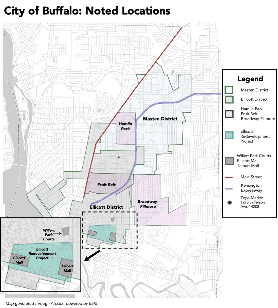
Within Buffalo’s borders, the Black population is heavily segregated. Main Street is regarded as the “dividing line” between primarily white and primarily Black neighborhoods. Of those who identify as Black alone, 72% live in areas east of Main Street, on Buffalo’s East Side. Ninety-four percent of tracts with a Black population above the City’s average are located east of Main Street. And every single tract where more than 60% of residents identify as Black are located east of Main Street.1
Residential segregation has tremendous adverse impacts on Black people and other communities of color: it limits access to healthcare, quality education, and economic stability. Law enforcement tends to be more invasive and intensive in segregated communities, making many residents feel like the police are an occupying force. Buffalo’s East Side reflects these broader trends of residential segregation exacerbated in the aftermath of the mass shooting. Despite local mutual aids and collectives stepping in to fundraise for residents directly impacted by the closing of Tops Market, it does not solve the city’s negligence in providing East Side residents an adequate standard of living.
Buffalo’s segregation is the result of intentional, legalized racism that was—and still is—baked into public policy and practices and has shaped the City’s history, geography, and people for over a century. While it is impossible to outline every root cause of modern segregation in Buffalo in a short essay, the main causes can be categorized generally within three themes: redlining and disinvestment; housing policy; and urban renewal and suburbanization.
Buffalo’s redlining dates back to the 1930s when city officials, politicians, and urban planners restricted the residential mobility of Black people, while simultaneously disinvesting in predominately Black and Brown neighborhoods. Restrictive covenants are added to deeds preventing the sale or use of land or property. Until 1948, it was legal to include race within a restrictive covenant to exclude non-white buyers. Although not heavily used in Erie County, evidence of thousands of restrictive covenants was discovered on property deeds in Tonawanda, Orchard Park, and other areas during early suburban development. The existence of these covenants made a lasting statement on who was—and wasn’t—welcome in these communities.
Redlining is one of the most well-known policies used in cities across the country to intentionally segregate communities. The Great Depression caused many home foreclosures and as part of the New Deal, the Federal Housing Agency (FHA) was formed to increase homeownership and, supposedly, allow easier access to manageable mortgages.
To do so, they mapped all urban areas and categorized neighborhoods from A to D, with ‘A’ being the most financially stable and ‘D’ being the least. Economists incorrectly held that Black residents and other residents of color would degrade property values. As a result, neighborhoods with high populations of color and those thought to have shifting demographics were put in the ‘C’ and ‘D’ categories, indicated by yellow and red on the maps. Even the wealthiest Black neighborhood in Buffalo at the time, Hamlin Park, was redlined.
Redlining created a “dual housing market” in which Black and white Americans were subject to different rules when applying for loans. It also prevented Black residents from taking advantage of an abundant housing market and accessible mortgages. Additionally, Redlining prevented access to loans for business development and property improvements in Black neighborhoods. It was not made illegal until the Fair Housing Act of 1968
In 1975 the Erie County Citizens Organization released a report indicating the root causes of blight in Buffalo were redlining and disinvestment, uncovering “high-risk maps” created by banks which continued to redline most of the Ellicott and Masten Districts. Even after the Community Reinvestment Act of 1977, the U.S. Banking Committee discovered it was twice as difficult to get a mortgage in Buffalo’s Black neighborhoods compared to its white neighborhoods.2 In 2014, Evans Bank was charged with redlining by the New York State Attorney General for creating a “trade area” map that excluded most of Buffalo’s East Side. And in 2021 New York State released a report with evidence of existing redlining by banks: under 10% of market-wide loans are made to people of color, half of what would be expected based on the region’s population.
Comparing original redlining maps to Buffalo’s current geography, the neighborhoods categorized as ‘C’ and ‘D’ are still predominantly communities of color nearly 90 years later.
Around the same time as redlining started in Buffalo, government-funded public housing reinforced residential segregation. Prevailing composition required all federally funded public housing projects, made possible by New Deal legislation, to accommodate residents of the same race as the surrounding neighborhood. Willert Park, completed in 1939 and located just east of downtown Buffalo, was the City’s first housing project constructed exclusively for Black residents. The segregation of Willert Park solidified the perception of the Ellicott District as “Buffalo’s Black neighborhood,” furthered by the construction of additional Black-only developments in subsequent years
Public housing continued to segregate Buffalo, as the Buffalo Municipal Housing Authority (BMHA) created housing developments like Ellicott and Talbert Malls, which were over 90% Black-occupied. When residents were relocated from one housing project to another, they were often moved intentionally based on race. And in 1989, despite multiple fair housing laws, the BMHA was charged with deliberate segregation within its public housing and among distribution of Section 8 vouchers.

Blockbusting was another tactic used by realtors and investors to buy properties in white neighborhoods that bordered Black neighborhoods and rent or sell them to Black families at above-market prices. They would then go to nearby white residents and convince them the neighborhood was shifting and they needed to sell their property quickly at a deflated price.
Blockbusting occurred throughout East Side neighborhoods like the Fruit Belt and Broadway-Filmore. It was also prevalent in the Masten District in the 1950s and ‘60s, as Black residents sought new places to live due to urban renewal displacement. Advocates got the City to pass a blockbusting ordinance in 1964. Even with this ordinance, and the practice made illegal by the Fair Housing Act of 1968, the Kensington-Leroy Community Association brought the issue to the Common Council in 1972.
Suburbanization and urban renewal projects throughout the 1950s and 1970s were some of the most damaging processes to Buffalo’s geography. On a national scale, it changed the landscape of American cities in the name of “progress,” almost always at the expense of communities of color. On a local scale, the Ellicott Redevelopment Project is a key example of a large-scale urban-renewal project which displaced over 2,000 families, over 80% of whom were Black. Black residents were then relocated to the Ellicott and Masten Districts. The Kensington Expressway is another example of urban renewal’s wrath. This project physically divided the East Side and permanently toreed the fabric of Black neighborhoods. The Kensington construction represents an apex of white convenience over Black lives.
Suburbanization drained Buffalo’s population, as those who were able to take advantage of the G.I. Bill purchased homes in the quickly developing suburbs. However, racist implementation of G.I. Bill benefits excluded many Black veterans. Furthermore, racist and exclusionary zoning laws (i.e., no multi-family homes) kept Buffalo’s suburbs primarily white. To this day, although diversifying slightly, most of Erie County’s municipalities are almost exclusively white. Only four (out offorty-three) have Black populations above 10%—one of which includes a correctional facility. Twenty municipalities have Black populations below 1%. Buffalo’s legacy of racism and segregation is neither new nor accidental. The May 14th tragedy was the first time many residents west of Main Street had to confront this evil. Buffalo’s segregation was deliberately created and perpetuated. Policy solutions to our region’s segregation must be equally as deliberate. Despite explicitly racist policies now being illegal, not enough has been done at any level of government to reverse the damage. Black people and other people of color must be at the forefront of these solutions. Only then will Buffalo truly live up to its nickname as the “City of Good Neighbors.”